

Source: MHCLG & Local Plans
Green Belt Map UK
Search any UK postcode or address to check whether a site falls inside a designated Green Belt boundary.
Last checked by Maplify: September 2026
Just want to see Green Belt coverage nationally without logging in?
Explore the free UK-wide Green Belt mapWhat This Layer Shows
The Green Belt layer outlines the designated boundary for each of England's 14 separate Green Belt areas, shown as a shaded polygon over the map. It includes the Metropolitan Green Belt around London (516,000 hectares) and the West Midlands, Greater Manchester, South & West Yorkshire and Merseyside Green Belts, along with smaller Green Belts around Cambridge, Oxford, York, Gloucester, Cheltenham, Bristol/Bath, Burton-on-Trent/Swadlincote, Nottingham/Derby and Stoke-on-Trent.
Green Belt is a planning policy designation, not a description of land ownership, land type or landscape quality — it covers roughly 1.6 million hectares, around 12.6% of England's land area, and includes farmland, woodland, golf courses, paddocks and, in places, previously developed land.
The boundary is drawn by the local planning authority and adopted through the Local Plan, so its precise line can vary in detail from the version shown on other national datasets until a formal review takes place. Where a site straddles the mapped line, part of the parcel is inside the designation and part is outside — this split matters for how an application is assessed.
Why It Matters
Green Belt status has a direct bearing on what a site can realistically be used for, so it is checked early in property, planning and development due diligence. Developers use it to screen sites before acquisition, planning consultants use it to advise on the prospects of an application, surveyors factor it into valuations, solicitors flag it during conveyancing, and land buyers use it to understand restrictions before committing to a purchase.
Identifying the designation early avoids wasted time and cost for anyone involved in a transaction, application or feasibility study. Green Belt status can also materially affect development prospects and land valuation, so it should be considered alongside Local Plan policy, access, infrastructure, environmental constraints and any emerging grey-belt or boundary-review position.
Because the purpose of Green Belt is explicitly to prevent urban sprawl, keep neighbouring towns separate, safeguard the countryside from encroachment, preserve historic towns and assist urban regeneration, its presence is one of the strongest single indicators of development risk anywhere in the English planning system.
How to Interpret the Map
Shaded green polygon
Area currently designated as Green Belt under the relevant Local Plan.
Boundary line
The precise edge of the designation as published by the local planning authority — sites straddling the line are split, part in and part out.
No shading
Land outside every mapped Green Belt boundary — this does not mean the site is free of other planning constraints.
Green Belt Layer in the Maplify Map
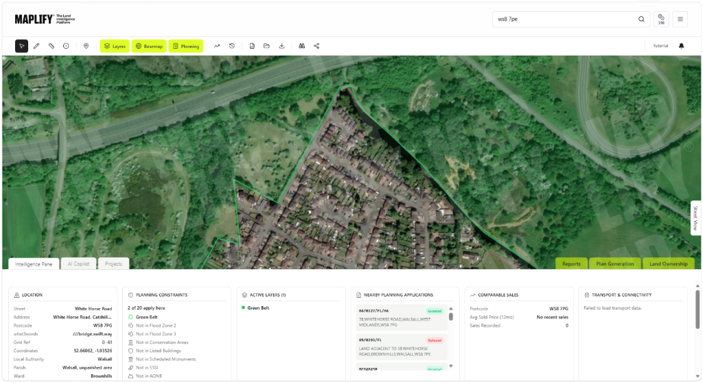
The Green Belt layer enabled on the Maplify map, showing a site's boundary against the designation alongside planning constraints, nearby applications and comparable sales data.
Planning and Development Implications
Green Belt does not prohibit every type of development — NPPF paragraphs 147–151 set out limited exceptions including agriculture, forestry, essential outdoor recreation and modest extensions to existing buildings. The table below summarises what is generally permitted, subject to local planning authority approval.
Most new development is treated as "inappropriate" and refused unless "very special circumstances" clearly outweigh the harm — this is a planning judgement, not something the map itself can determine. Even where an exception applies, the local planning authority will still assess scale, siting and impact on openness before granting consent.
Some sites are also affected by "grey belt" policy considerations and by local Green Belt reviews carried out as part of a Local Plan update — both can change what is realistically achievable on a site over time, even where the underlying boundary has not yet moved.
What to Do When a Site Is Affected
- 1Confirm the exact boundary with the local planning authority, since Local Plan reviews can move it.
- 2Check whether the proposed use falls under one of the limited exceptions (agriculture, forestry, outdoor recreation, modest extensions).
- 3If not, discuss "very special circumstances" with a planning consultant before submitting an application.
- 4Layer in Conservation Areas, Article 4 Directions and flood risk for the same site to build a full constraints picture.
- 5Factor the Green Belt designation into any offer or feasibility appraisal before committing to a purchase.
This is general guidance, not professional or legal advice — confirm specifics with the relevant authority or a qualified professional.
Official Data Source
Data Freshness
Important Limitations
- Green Belt boundaries shown on Maplify are indicative and intended for initial screening, not legal confirmation.
- A boundary may not yet reflect a very recent Local Plan review — always check with the local planning authority for the current position.
- Being outside the Green Belt does not mean a site is free of other planning constraints.
- Whether "very special circumstances" apply to a specific proposal is a planning judgement that Maplify cannot make.
Common Use Cases
Property Developers
Screen sites before acquisition to gauge development potential and likely planning risk.
Planning Consultants
Advise clients on the prospects of an application and whether "very special circumstances" arguments are viable.
Architects
Understand scale and design constraints early when shaping a scheme for a Green Belt site.
Surveyors
Factor Green Belt status into valuation and feasibility reports.
Solicitors
Flag Green Belt status during conveyancing due diligence for buyers and lenders.
Landowners
Understand what uses remain realistic before committing to disposal or development plans.
Related Layers
Green Belt status is rarely the only constraint that matters for a site.
Frequently Asked Questions
How do I check whether my property is in the Green Belt?
Open the Green Belt map on Maplify, search by postcode, address or location, then enable the Green Belt layer to see whether the boundary overlaps the site. You can add planning constraints and property boundary layers for further context.
Does Green Belt status prevent all development?
No. Most development is inappropriate in the Green Belt and is refused by default, but limited exceptions exist for agriculture, forestry, essential outdoor recreation and modest extensions to existing buildings. New development can occasionally proceed where "very special circumstances" clearly outweigh the harm.
Is Green Belt the same as greenfield land?
No. Green Belt is a planning policy designation intended to restrict development around certain towns and cities. Greenfield describes land that has not previously been developed, and it can exist both inside and outside the Green Belt.
Can Green Belt boundaries change?
Yes. Local planning authorities can review and amend Green Belt boundaries through their Local Plan process, usually only in exceptional circumstances. Boundaries shown on Maplify reflect the most recently published designations available from official sources.
Does Maplify cover every Green Belt area in England?
Maplify's Green Belt layer covers England's 14 separate Green Belt areas, including the Metropolitan Green Belt around London and the West Midlands, Greater Manchester, South & West Yorkshire and Merseyside Green Belts.
Is the Green Belt boundary shown on Maplify legally definitive?
No. Maplify is a screening tool. Boundaries are indicative and should be confirmed with the relevant local planning authority before making planning, purchasing or investment decisions.
Check Your Location on Maplify
Open the map, generate a site report or save your search to come back to it later.
References and Methodology
Reviewed by the Maplify data & editorial team
Maplify displays official-source data for desktop screening and due diligence. We document where each dataset comes from, how it is processed, when it is checked and where its limitations matter.