
Source: Local Planning Authorities
Article 4 Directions Map UK
Search any UK property to check whether permitted development rights have been removed, and which specific works now require planning permission.
Updated: as local authorities make new directions · Last checked by Maplify: August 2026
What This Layer Shows
This layer maps Article 4 Directions made by Local Planning Authorities under the Town and Country Planning (General Permitted Development) Order 2015. An Article 4 Direction removes specific permitted development rights within a defined area, meaning works that would normally be allowed without a planning application — extensions, roof alterations, cladding, window replacement, or a change of use — now require full planning permission.
Directions vary widely in scope: some cover a single conservation area and target only a handful of rights, such as cladding or window replacement, while others are "comprehensive" directions covering an entire town centre or residential area and removing a much broader set of rights, including conversion to Houses in Multiple Occupation (HMOs) or loss of employment land to residential use.
Why It Matters
Article 4 status changes what a homeowner or developer can legitimately assume is permitted development, and getting it wrong means carrying out unauthorised works that can trigger enforcement action. It is checked routinely during conveyancing, by planning consultants scoping a proposal, and by landlords or developers considering HMO conversion or change of use schemes.
Because directions are frequently paired with conservation area designation but can also exist independently — protecting employment land, agricultural character or residential amenity — checking this layer separately from conservation area status is essential to avoid missing a restriction that applies to a site outside any heritage designation.
How to Interpret the Map
Shaded area
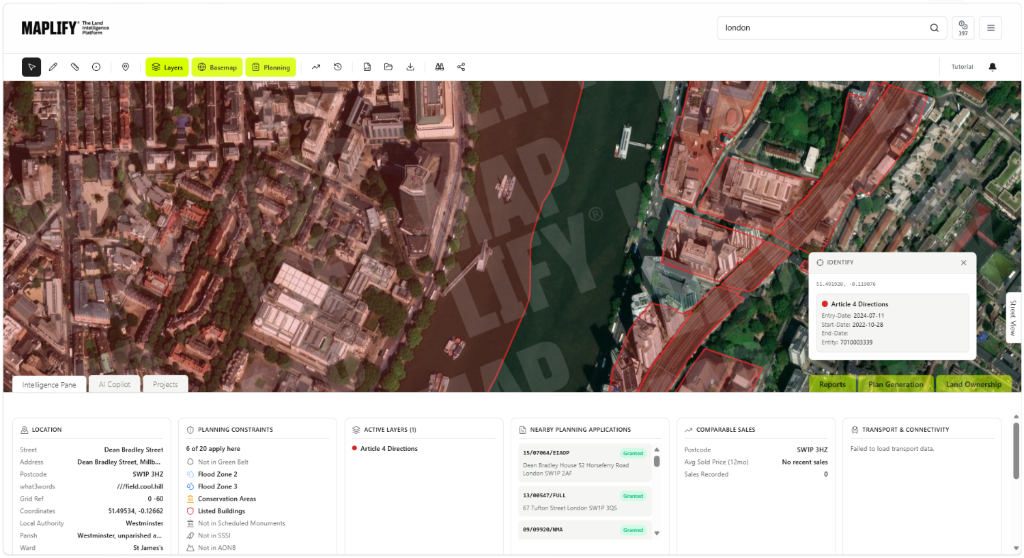
The boundary of the Article 4 Direction — check the popup for the specific permitted development classes removed within it.
Immediate direction
Takes effect without prior notice in urgent cases, typically where development is imminent and would cause harm before consultation could complete.
Non-immediate direction
Takes effect after a 12-month notice period and public consultation — the more common route.
Article 4 Directions Layer in the Maplify Map
Planning and Development Implications
Within an Article 4 area, works falling under the removed permitted development classes cannot proceed without a planning application, even where an equivalent property outside the area could carry out the same works without one. Common removed rights include roof alterations such as dormer windows and loft conversions, external wall cladding, window and door replacement in conservation areas, and change of use between certain classes.
For development or investment sites, a comprehensive Article 4 Direction removing permitted development rights to HMOs or removing employment land protections can materially change a scheme's viability, since a use that was assumed to be permitted development may in fact require a full application with no guarantee of approval.
What to Do When a Site Is Affected
- 1
Confirm the exact scope of the direction — which permitted development classes are removed — with the local planning authority.
- 2
Do not proceed with works assumed to be permitted development until the direction has been checked.
- 3
Budget time and cost for a full planning application if the proposed works fall within the removed rights.
- 4
Check the Conservation Areas and wider Planning Designations layers for the same site, since directions frequently overlap with other designations.
- 5
For HMO or change of use schemes, confirm current planning use class and any Article 4 restriction before committing to a purchase.
This is general guidance, not professional or legal advice — confirm specifics with the relevant authority or a qualified professional.
Official Data Source
Data Freshness
Important Limitations
- Article 4 boundaries shown on Maplify are for screening — confirm the exact removed permitted development classes with the local planning authority.
- A very recently made direction may not yet appear if the local authority has not published updated data.
- The specific rights removed vary between directions and are not always identical even within the same local authority — always check the individual direction document.
- This map does not replace formal confirmation of lawful development or a certificate of lawfulness application.
Common Use Cases
Property Developers
Confirm whether an assumed permitted development route actually requires a full application.
Planning Consultants
Advise clients on the scope of removed rights and the application route required.
Architects
Design proposals with the correct consent route in mind from the outset.
Solicitors
Flag Article 4 status during conveyancing due diligence for buyers, landlords and lenders.
Landowners
Understand which works now require permission before commissioning design or building work.
Surveyors
Factor Article 4 restrictions into valuation and lending risk assessments.
Related Layers
Article 4 checks are commonly run alongside these related layers.
Frequently Asked Questions
How do I check if my property is covered by an Article 4 Direction?
Search the property on Maplify and enable the Article 4 Directions layer. If a shaded area covers the property, check the popup for exactly which permitted development rights have been removed.
Does an Article 4 Direction ban development?
No. It removes specific permitted development rights, meaning works that would normally be allowed without an application — such as certain extensions or cladding — now require full planning permission.
Do Article 4 Directions always require public consultation?
Directions that take effect with less than 12 months' notice can be made without prior consultation in urgent cases, but most are consulted on and take effect after a 12-month notice period.
Are Article 4 Directions only used in conservation areas?
No. While many protect conservation area character, others remove rights to prevent HMO conversion, protect employment land from residential conversion, or safeguard agricultural land and shopfronts.
Does Article 4 status affect property value?
It can. Comprehensive Article 4 Directions covering common alteration or conversion rights are typically flagged in a Local Authority Search and can be a factor in valuation and lending decisions.
Can an Article 4 Direction be challenged or removed?
Directions can be varied or cancelled by the local planning authority, but this is uncommon; representations are usually made during the original consultation period rather than after the direction takes effect.
Check Article 4 Direction Status on Maplify
Open the map, generate a site report or save your search to come back to it later.
Dataset Details
| Provider | Local Planning Authorities / Planning.data.gov.uk |
| Geometry type | Polygon |
| Coverage | England |
| Update schedule | Quarterly check against published local authority directions |
| Reference date | August 2026 |
| Licence | Open Government Licence v3.0 |
Reviewed by the Maplify data & editorial team
Maplify displays official-source data for desktop screening and due diligence. We document where each dataset comes from, how it is processed, when it is checked and where its limitations matter.