
Property Boundaries
Land Registry Search
Maplify helps you search and view Land Registry boundary data alongside planning and environmental constraints. Use it to understand a site's boundary context, neighbouring titles and key risks before buying, designing or appraising land.
Editorial review
Reviewed by the Maplify Editorial Team. Editorial policy
Primary source
Verification
Last checked September 2026. Methodology · Corrections
Search Land Registry boundaries by address or postcode
Find a site on the map, view HM Land Registry INSPIRE title polygons and combine the boundary with planning and environmental constraints.
Maplify is a screening and due-diligence tool. Verify critical planning, legal and environmental matters with the relevant authority or qualified professional.
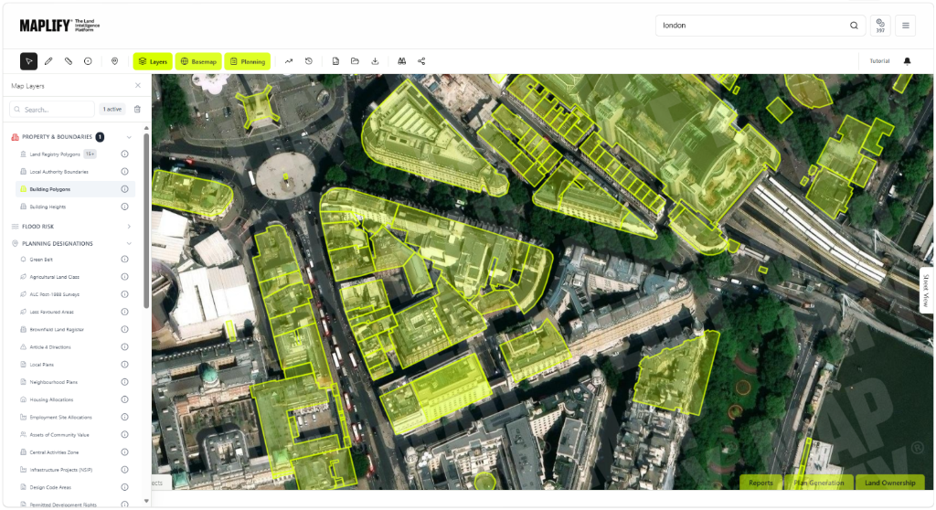
Search by Location
Click to Query
Title Information
Export Data
Property & Boundary Data Layers
How to Search Land Registry Data
- 1
Enter a postcode, address or title number to find your property.
- 2
Toggle on the Land Registry layer (visible at zoom level 17+).
- 3
Click any property boundary to see the title number and access title documents.
HM Land Registry INSPIRE Index Polygons: Complete Guide to UK Property Boundary Data
The HM Land Registry INSPIRE Index Polygons dataset provides digital representations of all registered property boundaries in England and Wales, covering over 25 million registered titles. This comprehensive open data complies with the EU INSPIRE Directive (Infrastructure for Spatial Information in the European Community), providing standardized cadastral parcel mapping for property research, planning, development feasibility and conveyancing.
What is a Land Registry Title Number? Understanding Property Registration
Every registered freehold property and leasehold property in England and Wales is allocated a unique title number by HM Land Registry. Title numbers follow formats like AB123456 where AB represents the Land Registry office district (e.g., WM = West Midlands, K = Kent, DN = Durham & Northumberland).
Each title number links to two documents essential for property ownership verification:
- Title Register: Legal description of the property including ownership details, purchase price (if sold after 2000), mortgages and charges, restrictive covenants, easements, rights of way, and notices
- Title Plan: Ordnance Survey-based map showing the general boundaries of the registered land outlined in red, with any land benefiting from rights coloured green or blue
Official copies of title documents cost £3 per document from HM Land Registry's online service. Maplify provides free access to INSPIRE boundary polygons with direct links to purchase official title documents.
General Boundaries Rule: Why Land Registry Plans Are Not Legally Definitive
HM Land Registry operates under the general boundaries rule established by Section 60 of the Land Registration Act 2002. This means title plans show the approximate position of boundaries, not the exact legal line. Key implications of general boundaries:
- The red line on title plans is drawn to the inside of physical features like walls, fences and hedges visible on Ordnance Survey mapping
- The exact legal boundary line is not determined by the title plan unless specifically fixed as a determined boundary
- Measurements scaled from title plans cannot establish precise boundary positions for boundary dispute resolution
- Physical features visible on the ground (walls, fences, hedges) typically define the actual legal boundary position, not the red line on the plan
- INSPIRE polygons inherit this approximate accuracy — suitable for identification but not legal boundary determination
Need a precise boundary?
INSPIRE Polygon Accuracy: Limitations and Appropriate Uses for Property Research
INSPIRE Index Polygons are based on Ordnance Survey mapping at 1:1250 scale (urban areas) or 1:2500 scale (rural areas), giving positional accuracy of approximately ±1–2 metres. Polygon areas calculated from INSPIRE data typically vary ±5–10% from official title register stated areas.
Appropriate Uses for INSPIRE Boundary Data
INSPIRE polygons are well suited to desktop research and early-stage screening:
- Title number identification: finding title numbers for properties to order official copies — highly effective
- Ownership mapping: desktop assessment of land ownership patterns for development assembly — suitable for feasibility stage
- Planning constraint overlay: overlaying flood zones, green belt, SSSI, listed buildings on land parcels — appropriate for desktop studies
- Approximate area calculations: estimating site areas for initial viability — acceptable with caveats acknowledging accuracy limitations
- Red line applications: initial planning application site boundaries — must be refined using OS base maps
Inappropriate Uses — When INSPIRE Data Is Insufficient
- Legal boundary evidence: INSPIRE polygons are not admissible evidence in boundary dispute proceedings or court cases
- Precise measurements: cannot be used for calculating definitive site areas for sale contracts or construction drawings
- Determined boundaries: cannot substitute for professional surveys where exact boundary lines are required
- Mortgage lending: lenders require official title plans, not INSPIRE data, for security descriptions
Maplify's INSPIRE viewer clearly labels data as approximate and provides links to order official title documents for definitive boundary information.
Using Land Registry Data for Property Development: Site Assembly and Ownership Verification
Property developers use Land Registry title data throughout development processes:
Feasibility and Site Identification
- Ownership patterns: Identify fragmented or consolidated land ownership affecting site assembly prospects
- Ransom strips: Spot narrow parcels owned by third parties that could block development access
- Access rights: Check for registered rights of way or access across adjoining land
- Constraints: Overlay boundaries with planning designations to assess developable area
Due Diligence and Land Acquisition
- Title investigation: Order official copies revealing ownership, charges, restrictive covenants
- Ownership verification: Confirm seller owns land being sold by checking registered proprietor
- Charge checks: Identify existing mortgages requiring discharge at completion
- Restriction checks: Discover restrictions limiting dealings or requiring consents
Planning Application Stage
- Red line boundary: Define the application site boundary accurately on OS base maps using INSPIRE as a starting reference
- Blue line land: Identify additional land under applicant control required for Certificate B/C/D ownership certificates
- Notice serving: Identify landowners requiring Article 12 notice of planning application (owners of land within the application site or Agricultural Holdings Act notices)
View Land Registry boundaries overlaid with planning constraints on Maplify for comprehensive development site assessment.
Frequently Asked Questions
Can I search Land Registry boundaries on a map?
Yes. Maplify displays HM Land Registry INSPIRE Index Polygons on an interactive map, showing property boundaries and title numbers.
Are Land Registry boundaries exact?
No. Land Registry operates under the general boundaries rule. Title plans show approximate boundary positions, not the exact legal line. A professional survey is required for precise boundary determination.
Can I combine Land Registry data with planning constraints?
Yes. Maplify allows you to view Land Registry boundaries alongside flood risk, Green Belt, heritage, environmental and other constraint layers.
Is Maplify suitable for legal boundary disputes?
No. INSPIRE polygon data is not admissible as legal evidence in boundary disputes. A professional boundary survey and legal advice are required for disputes.
Can I see who owns land?
Maplify shows title polygon boundaries and title reference numbers. To find owner details, you would need to purchase the official title register from HM Land Registry.
Start Your Land Registry Search
Access property boundaries and title numbers for free — ${FREE_SEARCH_ALLOWANCE} searches per ${FREE_SEARCH_ALLOWANCE_PERIOD}, no sign-up fee.
Open Map Viewer