

Source: Historic England National Heritage List
Listed Buildings Map UK
Search any UK address to check whether it — or a neighbouring building — is listed, at what grade, and what that means for alterations.
Last checked by Maplify: August 2026
What This Layer Shows
This layer plots every entry on the National Heritage List for England, marking the location and grade of each listed building. There are around 400,000 listed buildings in England, graded I (exceptional interest, around 2.5%), II* (particularly important, around 5.5%) or II (nationally important and of special interest, around 92%).
Listing protects a building of special architectural or historic interest, and can extend to structures within its curtilage — outbuildings, walls and garden features within the grounds — as well as to the building's setting, meaning development on neighbouring land can also be affected.
Why It Matters
Listed status controls what alterations a building — or in some cases its neighbours — can undergo, making it one of the first checks for anyone planning works, buying a period property or assessing a development site near a heritage asset. Unauthorised works to a listed building are a criminal offence, so confirming status before work begins avoids significant legal and financial risk.
For property buyers, listed status is disclosed in conveyancing searches and can affect insurance premiums, available mortgage products and the realistic scope of future renovation — all factors best understood before making an offer, not after exchange.
How to Interpret the Map
Grade I
Buildings of exceptional interest, sometimes internationally significant — roughly 2.5% of listed buildings.
Grade II*
Particularly important buildings of more than special interest — around 5.5% of listings.
Grade II
Buildings of national importance and special interest — the majority of listings, around 92%.
Listed Buildings Layer in the Maplify Map
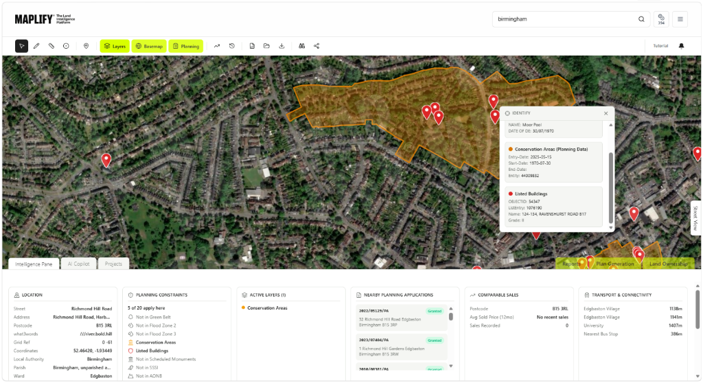
The Listed Buildings layer enabled on the Maplify map, showing listed building markers alongside conservation area boundaries and nearby planning applications.
Planning and Development Implications
Listed building consent is required for any works that would affect a listed building's character, whether internal or external, and this sits alongside standard planning permission where that is also needed. Consent applications require more detailed heritage justification than a typical planning application, and local authorities can refuse works that harm the building's significance.
Development proposals on land adjoining a listed building must also demonstrate that the building's setting is preserved or enhanced — this is assessed under the Planning (Listed Buildings and Conservation Areas) Act 1990 and is a common reason for refusal or design amendment on sites near heritage assets.
What to Do When a Site Is Affected
- 1Confirm the exact list entry and grade with Historic England's National Heritage List before planning any works.
- 2Commission a heritage statement if alterations, extensions or demolition of any part of the building are proposed.
- 3Apply for listed building consent alongside any required planning permission — do not start works before consent is granted.
- 4If developing nearby land, assess and document the impact on the listed building's setting as part of the application.
- 5Check the Conservation Areas and Scheduled Monuments layers for the same site, since these designations frequently overlap.
This is general guidance, not professional or legal advice — confirm specifics with the relevant authority or a qualified professional.
Official Data Source
Data Freshness
Important Limitations
- Listed building markers are for screening — always confirm the exact list entry and description with Historic England before relying on it.
- Curtilage listing (structures within the grounds) is not always separately mapped and may require a heritage consultant's assessment.
- A very recently listed or delisted building may not yet appear if Historic England has not published updated data.
- This map does not replace a heritage statement or pre-application advice for significant works.
Common Use Cases
Property Developers
Assess heritage risk and setting impact before acquiring a site near a listed building.
Planning Consultants
Advise on listed building consent requirements and heritage justification for proposals.
Architects
Design alterations that respect a building's special interest from the outset.
Surveyors
Factor listed status into condition surveys and valuations.
Solicitors
Flag listed status during conveyancing due diligence for buyers and lenders.
Landowners
Understand consent requirements before commissioning renovation or extension works.
Related Layers
Listed building checks are commonly run alongside these related layers.
Frequently Asked Questions
How do I check if a building is listed?
Search the address on Maplify and enable the Listed Buildings layer. If a marker appears on the property, it is listed — the popup shows the grade and the official list entry.
What is the difference between Grade I, II* and II listing?
Grade I covers buildings of exceptional interest (around 2.5% of listings), Grade II* covers particularly important buildings of more than special interest (around 5.5%), and Grade II covers buildings of national importance and special interest (around 92%). All three grades carry the same legal consent requirements.
Can I make changes to a listed building without permission?
Listed building consent is required for any works affecting a listed building's special architectural or historic character, both internally and externally, in addition to standard planning permission where that also applies. Unauthorised works are a criminal offence.
Does listing affect land or buildings near a listed building?
Listing can extend to structures within the curtilage (grounds) of the listed building, and it is a material consideration for development on neighbouring land where the proposal would affect the listed building's setting.
How does listed status affect a property purchase or mortgage?
It is disclosed during conveyancing searches and can affect insurance costs, mortgage terms and future alteration plans, so it is a standard check before exchange.
Are there other heritage designations I should check alongside listing?
Yes — conservation areas, scheduled monuments and registered parks and gardens frequently overlap with listed buildings and carry their own separate consent requirements.
Check Listed Building Status on Maplify
Open the map, generate a site report or save your search to come back to it later.
Reviewed by the Maplify data & editorial team
Maplify displays official-source data for desktop screening and due diligence. We document where each dataset comes from, how it is processed, when it is checked and where its limitations matter.