

Source: Natural England
SSSI Map & Impact Risk Zone Checker
Search any location in England to check whether a site falls within an SSSI or an SSSI Impact Risk Zone before you buy, plan or develop.
Last checked by Maplify: September 2026
What This Layer Shows
This layer maps Sites of Special Scientific Interest (SSSIs) notified by Natural England (or Natural Resources Wales / NatureScot outside England) for their exceptional flora, fauna, geological or physiographical features, together with each site's impact risk zone. There are over 4,100 SSSIs in England alone, covering roughly 8% of the country's land area, ranging from lowland heath and ancient woodland to chalk grassland, wetlands and geological exposures.
Each SSSI is divided into management units that Natural England assesses individually for condition — favourable, unfavourable recovering, or unfavourable no change/declining — which is a factor in how much weight a proposal affecting the site is likely to be given in a planning decision.
Why It Matters
SSSI status is the UK's premier national conservation designation, and development that could damage a notified site faces one of the strictest consultation and consent regimes in the planning system. Developers and ecologists check this layer at the earliest feasibility stage, because a site within or near an SSSI can require specialist ecological survey work — sometimes across multiple seasons — before an application can even be validated.
The impact risk zone extends this check beyond the SSSI boundary itself: certain development types trigger mandatory Natural England consultation purely by virtue of proximity, even where the application site is entirely outside the designated area, which is a detail commonly missed without checking the layer directly.
How to Interpret the Map
SSSI boundary
The notified site boundary — operations likely to damage its special features require consent from Natural England.
Impact risk zone
A buffer area around the SSSI where specific development types trigger mandatory Natural England consultation.
Unit condition (where shown)
Favourable, unfavourable recovering, or unfavourable no change/declining — an indicator of the site's current ecological health.
SSSI Layer in the Maplify Map
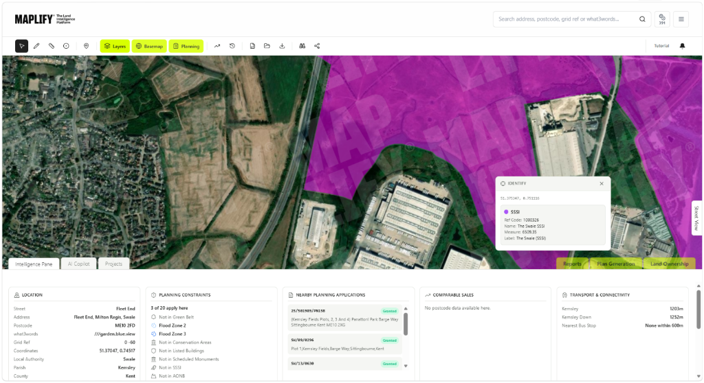
The SSSI layer enabled on the Maplify map, showing the notified site boundary alongside nearby planning applications and comparable sales data.
Planning and Development Implications
Under the Wildlife and Countryside Act 1981, operations likely to damage an SSSI's notified special features require consent, and local planning authorities are under a statutory duty to consult Natural England on any application affecting an SSSI or falling within its impact risk zone. Natural England can object, requiring further survey or mitigation before an application proceeds.
Development affecting an SSSI is not automatically refused, but the evidential bar to demonstrate no significant harm — or to justify harm against a clear public benefit — is high, and additional survey seasons are often needed to establish baseline ecological conditions before a scheme can be assessed.
What to Do When a Site Is Affected
- 1Confirm the exact SSSI boundary, unit condition and impact risk zone with Natural England's designated sites system.
- 2Commission an ecological survey early, since some habitats require seasonal surveys that can only be carried out at certain times of year.
- 3Engage Natural England pre-application if the proposal falls within the impact risk zone or could affect the SSSI's special features.
- 4Consider mitigation or compensation measures if avoidance of harm is not achievable.
- 5Check the Special Areas of Conservation, Ancient Woodland and Nature Reserves layers for the same site for the fuller ecological picture.
This is general guidance, not professional or legal advice — confirm specifics with the relevant authority or a qualified professional.
Official Data Source
Data Freshness
Important Limitations
- SSSI boundaries shown on Maplify are for screening — always confirm the exact boundary and current unit condition with Natural England.
- Impact risk zone rules vary by development type and are not fully replicated on the map — confirm specific triggers with the local planning authority.
- A very recent notification or boundary amendment may not yet appear if Natural England has not published updated data.
- This map does not replace a professional ecological survey for a site within or near an SSSI.
Common Use Cases
Property Developers
Screen sites for SSSI or impact risk zone constraints before committing to acquisition.
Environmental Consultants
Scope ecological surveys and Natural England pre-application engagement.
Planning Consultants
Advise on consultation requirements and the likely evidential bar for an application.
Architects
Design layouts that avoid or minimise impact on notified habitat from the outset.
Surveyors
Factor SSSI proximity into valuation and feasibility reports.
Landowners
Understand consent requirements before commissioning agricultural, forestry or land management works.
Related Layers
SSSI checks are commonly run alongside these related layers.
Related Guides
Frequently Asked Questions
How do I check if a site is an SSSI or near one?
Search the site on Maplify and enable the SSSI layer alongside SSSI Impact Risk Zones. If the site falls within either, Natural England consultation will likely be required for planning applications.
What is an SSSI impact risk zone?
A buffer area around an SSSI where certain development types — such as housing above a threshold size, or specific agricultural or forestry operations — trigger mandatory consultation with Natural England, even though the site itself sits outside the SSSI boundary.
Can I develop on land within an SSSI?
Operations likely to damage an SSSI's special features require consent under the Wildlife and Countryside Act 1981, and local planning authorities must consult Natural England on any application affecting an SSSI. Development is not banned outright but faces a very high bar.
What does SSSI unit condition mean?
Each SSSI is divided into management units independently assessed for condition — "favourable", "unfavourable recovering" or "unfavourable no change/declining" — which can affect the weight given to potential harm in a planning decision.
Is an SSSI the same as a Special Area of Conservation (SAC)?
No, though they often overlap. SSSI is a national UK designation; SAC is an internationally important designation under the Habitats Regulations, generally carrying an even higher level of protection.
How many SSSIs are there in England?
There are over 4,100 SSSIs in England, covering roughly 8% of the country's land area, ranging from wetlands and heathland to geological exposures and ancient woodland.
Check SSSI Status on Maplify
Open the map, generate a site report or save your search to come back to it later.
References and Methodology
Reviewed by the Maplify data & editorial team
Maplify displays official-source data for desktop screening and due diligence. We document where each dataset comes from, how it is processed, when it is checked and where its limitations matter.