


Source: Historic England National Heritage List
Scheduled Monuments Map UK
Search any UK location to check whether a site contains or is near a Scheduled Monument before you buy, plan or develop.
Last checked by Maplify: August 2026
What This Layer Shows
This layer plots Scheduled Monuments — nationally important archaeological sites and historic structures given legal protection under the Ancient Monuments and Archaeological Areas Act 1979. There are around 20,000 in England, ranging from prehistoric barrows, hillforts and Roman remains to medieval castles, deserted villages and industrial archaeology sites.
Unlike listed buildings, scheduling protects the below-ground archaeology as well as any visible structure, meaning even a site with no obvious surface features can be scheduled and subject to strict consent requirements for any groundworks.
Why It Matters
Scheduled Monument status carries the strictest protection of any UK heritage designation, and unauthorised disturbance is a criminal offence, independent of whether planning permission has been granted for the same works. Developers, archaeologists and planning consultants check this layer at the earliest possible stage because Scheduled Monument Consent is a wholly separate application process from planning permission, with its own timescales and evidential requirements.
Because protection extends below ground, a site can be affected even where there is nothing visible on the surface — making this one of the easiest heritage constraints to miss without checking the official record directly.
How to Interpret the Map
Scheduled area
The boundary of the Scheduled Monument, covering both visible remains and below-ground archaeology.
Setting
Land around the monument that contributes to how it is experienced and understood — not separately mapped, but a material planning consideration.
Scheduled Monuments Layer in the Maplify Map
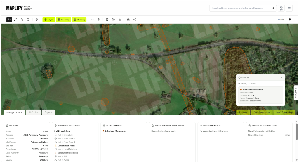
The Scheduled Monuments layer enabled on the Maplify map, showing the scheduled boundary alongside nearby planning applications and comparable sales data.
Planning and Development Implications
Scheduled Monument Consent — separate from planning permission — is required for almost any works affecting a scheduled site, including excavation, groundworks, fencing, deep ploughing and metal detecting. Consent applications are made to Historic England on behalf of the Secretary of State and can take significantly longer to determine than a standard planning application.
Development affecting a monument's setting can also be refused even where the scheduled area itself is untouched, so proposals on adjoining land need to demonstrate the monument's significance and setting are preserved.
What to Do When a Site Is Affected
- 1Confirm the exact scheduled boundary and monument description with Historic England's National Heritage List.
- 2Apply for Scheduled Monument Consent before any groundworks, in addition to any required planning permission.
- 3Commission an archaeological desk-based assessment early, since consent timescales can be longer than standard planning applications.
- 4Assess and document any impact on the monument's setting if developing adjoining land.
- 5Check the Listed Buildings and Conservation Areas layers for the same site, since heritage designations frequently overlap.
This is general guidance, not professional or legal advice — confirm specifics with the relevant authority or a qualified professional.
Official Data Source
Data Freshness
Important Limitations
- Scheduled Monument boundaries are for screening — always confirm the exact boundary and description with Historic England before any works.
- Below-ground archaeology may extend beyond the mapped boundary; a desk-based assessment or field evaluation may still be required nearby.
- A very recently scheduled site may not yet appear if Historic England has not published updated data.
- This map does not replace an application for Scheduled Monument Consent or archaeological advice.
Common Use Cases
Property Developers
Identify Scheduled Monument Consent requirements before committing to a site.
Planning Consultants
Advise on the separate consent process and likely timescales.
Architects
Design around protected areas and setting considerations from the outset.
Surveyors
Factor scheduling into valuation and feasibility reports.
Landowners
Understand consent requirements before commissioning any groundworks.
Environmental Consultants
Coordinate archaeological assessments alongside ecological surveys.
Related Layers
Scheduled Monument checks are commonly run alongside these related layers.
Related Guides
Frequently Asked Questions
How do I check if a site contains a Scheduled Monument?
Search the site on Maplify and enable the Scheduled Monuments layer. If a marker or boundary covers the site, Scheduled Monument Consent is likely required before any groundworks.
What is the difference between a Scheduled Monument and a Listed Building?
Listing protects a building's architectural or historic interest, largely above ground. Scheduling protects nationally important archaeological remains, including below-ground archaeology, and applies a separate, generally stricter consent regime than listed building consent.
Do I need permission to dig on land with a Scheduled Monument?
Yes. Scheduled Monument Consent is required for almost any works affecting a scheduled site, including groundworks, fencing, ploughing below normal depth and metal detecting — unauthorised disturbance is a criminal offence.
Can development happen near a Scheduled Monument even if not on it?
Development affecting a monument's setting — the surrounding land that contributes to how it is understood and experienced — can be refused even where the monument itself is untouched.
How many Scheduled Monuments are there in England?
There are around 20,000 Scheduled Monuments in England, ranging from prehistoric barrows and Roman remains to castles, deserted medieval villages and industrial archaeology.
Who grants Scheduled Monument Consent?
Applications are made to Historic England on behalf of the Secretary of State, independently of the normal local planning authority process — a separate application from any planning permission required for the same works.
Check Scheduled Monument Status on Maplify
Open the map, generate a site report or save your search to come back to it later.
Reviewed by the Maplify data & editorial team
Maplify displays official-source data for desktop screening and due diligence. We document where each dataset comes from, how it is processed, when it is checked and where its limitations matter.