

Source: Environment Agency
Source Protection Zones Map UK
Search any UK location to check whether it falls within SPZ 1, 2 or 3 groundwater protection zones before you buy, plan or develop.
Updated: as the Environment Agency revises hydrogeological modelling · Last checked by Maplify: August 2026
What This Layer Shows
This layer maps Source Protection Zones (SPZs), calculated by the Environment Agency using hydrogeological modelling of groundwater flow and pollutant travel time from the surface to a public drinking water abstraction point. The three-zone system provides graduated protection based on how quickly pollution could reach the source: SPZ 1 (Inner Zone, 50 days travel time), SPZ 2 (Outer Zone, 400 days travel time) and SPZ 3 (Total Catchment, the full groundwater catchment feeding the source).
SPZ 1 carries the strictest controls, since pollution here can reach the drinking water source within days to weeks. SPZ 2 and SPZ 3 provide more time for pollutants to be diluted or degraded before reaching the source, and controls loosen accordingly, though cumulative impacts across the whole catchment are still assessed.
Why It Matters
SPZ status directly affects what activities the Environment Agency will permit on a site, and the difference between SPZ 1 and SPZ 3 can be the difference between an activity being prohibited outright or approved subject to routine conditions. Developers assessing residential, industrial or agricultural sites check this layer to understand permit requirements early, since environmental permit applications can add significant time to a project programme.
For rural properties specifically, SPZ 1 status can also affect septic tank options, sometimes forcing an expensive mains sewerage connection — a cost that is best identified before exchange rather than after completion.
How to Interpret the Map
SPZ 1 — Inner Zone (50 days)
Highest protection. Landfill and new fuel storage are prohibited; most potentially polluting activities require permits or are refused.
SPZ 2 — Outer Zone (400 days)
Medium protection. Controlled activities such as fuel storage and septic tanks are permitted with conditions and risk assessment.
SPZ 3 — Total Catchment
Lower risk but still protected. Major developments and cumulative agricultural impacts are assessed for long-term water quality.
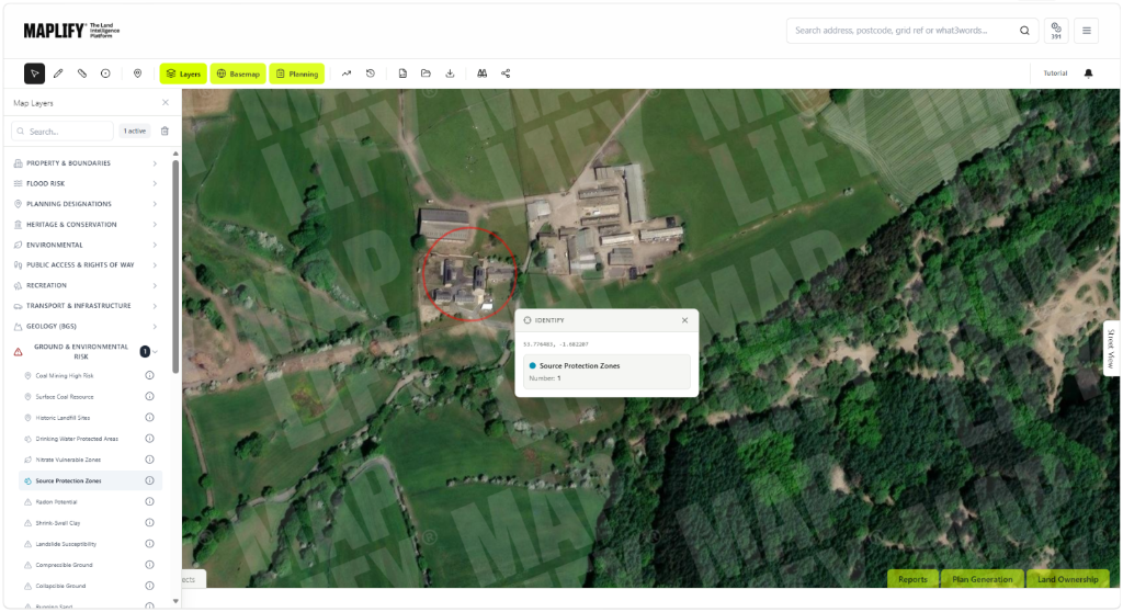
Source Protection Zones Layer in the Maplify Map
Planning and Development Implications
Discharges to ground, borehole works, dewatering and certain waste activities within an SPZ commonly require an Environmental Permit from the Environment Agency, in addition to any planning permission needed for the development itself. The table below summarises how common activities are generally treated across the three zones.
Mains-connected residential development is generally straightforward across all three zones, while activities involving discharge to ground or fuel storage face much closer scrutiny, particularly in SPZ 1.
What to Do When a Site Is Affected
- 1Confirm the exact SPZ classification and boundary with the Environment Agency.
- 2Identify whether the proposed activity requires an Environmental Permit before submitting a planning application.
- 3For sites without mains sewerage, check whether a septic tank is restricted and budget for a mains connection if needed.
- 4Check the Contaminated Land and Nitrate Vulnerable Zones layers for the same site for the fuller water quality picture.
- 5Engage the Environment Agency pre-application for any activity involving discharge, fuel storage or groundwater abstraction.
This is general guidance, not professional or legal advice — confirm specifics with the relevant authority or a qualified professional.
Official Data Source
Data Freshness
Important Limitations
- SPZ boundaries are modelled estimates based on hydrogeology, not surveyed lines — treat them as indicative for initial screening.
- Permit and consultation requirements depend on the specific activity proposed, not just the zone alone.
- This map does not replace a groundwater risk assessment or confirmation from the Environment Agency.
- SPZs often overlap with Nitrate Vulnerable Zones — check both for agricultural land.
Common Use Cases
Property Developers
Assess permit requirements before committing to a site with a discharge or drainage proposal.
Environmental Consultants
Scope groundwater risk assessments and permit applications.
Planning Consultants
Advise on the interaction between planning permission and Environment Agency permits.
Surveyors
Flag septic tank restrictions and mains connection costs during property surveys.
Landowners
Understand agricultural and land management restrictions within a zone.
Solicitors
Confirm SPZ status during conveyancing due diligence for rural properties.
Related Layers
Groundwater protection checks are usually run alongside these related layers.
Related Guides
Frequently Asked Questions
What is a Source Protection Zone?
A Source Protection Zone is an area around a public drinking water source — a borehole, spring or well — designated by the Environment Agency to protect groundwater from pollution. SPZ 1 is the inner zone, SPZ 2 the outer zone, and SPZ 3 the total catchment feeding the source.
Can I build in a Source Protection Zone?
Often yes, but with restrictions that increase closer to the source. SPZ 1 carries the strictest controls — landfill and new fuel storage are prohibited — while SPZ 2 and 3 allow more development subject to pollution prevention conditions and Environment Agency consultation.
Do I need an environmental permit if my site is in an SPZ?
Potentially. Discharges to ground, borehole works, dewatering and certain waste activities in an SPZ commonly require an Environmental Permit from the Environment Agency — check directly with them for your specific proposal.
How does SPZ status affect septic tanks?
New septic tanks discharging to ground are generally prohibited in SPZ 1 and restricted in SPZ 2. Existing systems may need upgrading or connection to mains sewerage, which can cost £20,000–£40,000 for rural properties.
Do Source Protection Zones overlap with Nitrate Vulnerable Zones?
Yes, in many agricultural areas. Where they overlap, the more restrictive rules from each designation both apply — check both layers together for farmland.
Is the SPZ boundary shown here legally definitive?
No. It is a screening tool. Confirm boundaries and permit requirements directly with the Environment Agency before relying on them for a transaction or planning application.
Check Source Protection Zones on Maplify
Open the map, generate a site report or save your search to come back to it later.
References and Methodology
Reviewed by the Maplify data & editorial team
Maplify displays official-source data for desktop screening and due diligence. We document where each dataset comes from, how it is processed, when it is checked and where its limitations matter.