


Source: Defra Strategic Noise Mapping
Noise Maps UK
Search any UK location to check strategic road and rail noise levels and Noise Important Areas before you buy, plan or develop.
Updated: periodically under the Environmental Noise Directive cycle · Last checked by Maplify: August 2026
What This Layer Shows
This layer maps Defra's strategic noise data, modelling day-evening-night (Lden) average noise levels from major roads and railways across England, together with Noise Important Areas — the worst 1% of noise-affected locations nationally, identified for priority mitigation action under national noise policy.
Noise bands are modelled in a series of decibel ranges, allowing a site to be screened for its general noise exposure category before any site-specific measurement or assessment is commissioned.
Why It Matters
Noise exposure directly affects the viability and design of residential development near busy roads or railways, since local planning authorities require internal noise standards to be met for habitable rooms under the Noise Policy Statement for England. Developers and architects check this layer early because acoustic mitigation — enhanced glazing, mechanical ventilation, layout changes — can add meaningful cost and needs to be factored into scheme design from the outset, not retrofitted after a refusal.
A site falling within a Noise Important Area faces particularly close scrutiny, since national policy specifically flags these locations as priorities for improvement rather than further noise-generating development without robust mitigation.
How to Interpret the Map
Road & Rail Noise (Lden)
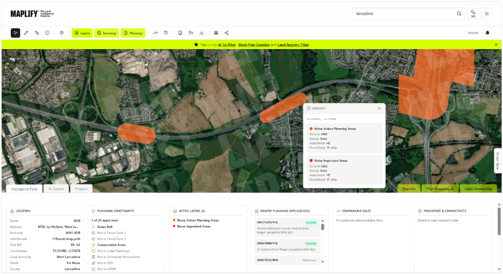
Modelled day-evening-night average noise levels from major roads and railways, published in noise bands.
Noise Important Area
The worst 1% of noise-affected locations nationally, prioritised for mitigation action.
Noise Layers in the Maplify Map
Planning and Development Implications
Residential development in a high-noise area, or within a Noise Important Area, typically requires a noise impact assessment demonstrating that internal noise levels in habitable rooms can meet relevant standards, alongside external amenity space noise where applicable. Mitigation commonly includes enhanced glazing specifications, mechanical ventilation to allow windows to remain closed for noise control, acoustic fencing, and layout designs that set back or shield habitable rooms from the noise source.
Where mitigation cannot adequately address noise exposure, a scheme can be refused on residential amenity grounds, so early testing of the noise environment is an important part of feasibility work for sites near major transport corridors.
What to Do When a Site Is Affected
- 1Confirm the modelled noise band and any Noise Important Area status with the local authority or Defra data.
- 2Commission a noise impact assessment for residential schemes in higher noise bands.
- 3Design glazing, ventilation and layout solutions to meet internal noise standards from the outset.
- 4Check the Air Quality layer for the same site, since noisy roads and poor air quality frequently coincide.
- 5Engage an acoustic consultant early for sites within or adjacent to a Noise Important Area.
This is general guidance, not professional or legal advice — confirm specifics with the relevant authority or a qualified professional.
Official Data Source
Data Freshness
Important Limitations
- Modelled noise bands are for screening — always confirm site-specific exposure with a professional noise assessment.
- Strategic noise maps focus on major roads and railways and may not capture minor local roads or industrial noise sources.
- This map does not replace a noise impact assessment for a planning application.
- Noise data is republished periodically and may not reflect very recent changes to traffic volumes or rail schedules.
Common Use Cases
Property Developers
Screen sites for acoustic mitigation requirements before committing to a scheme.
Environmental Consultants
Scope noise impact assessments and mitigation strategies.
Architects
Design glazing, ventilation and layout solutions from the outset.
Planning Consultants
Advise on likely conditions and the evidential bar for residential amenity.
Surveyors
Factor noise exposure into valuation and feasibility reports.
Landowners
Understand development constraints before commissioning design work.
Related Layers
Noise checks are commonly run alongside these related layers.
Related Guides
Frequently Asked Questions
How do I check noise levels for a site?
Search the site on Maplify and enable the Road Noise, Rail Noise and Noise Important Areas layers to see modelled day-evening-night (Lden) noise exposure for that location.
What is a Noise Important Area?
The worst 1% of noise-affected locations nationally, identified from strategic noise mapping and prioritised for mitigation action under the national noise strategy.
Does high noise exposure block residential development?
Not automatically, but it typically requires a noise impact assessment and acoustic mitigation — such as enhanced glazing, mechanical ventilation or layout changes — to meet internal noise standards set out in the Noise Policy Statement for England and relevant British Standards.
What noise mitigation measures are commonly required?
Enhanced double or triple glazing, mechanical ventilation to allow windows to remain closed, acoustic fencing, and layout designs that place habitable rooms away from the noise source are all common conditions.
Is strategic noise mapping updated regularly?
Defra republishes strategic noise maps periodically under the Environmental Noise Directive framework, typically every five years, alongside interim Noise Important Area reviews.
Does noise data cover aircraft noise too?
This layer focuses on road and rail noise mapping. Aircraft noise is separately modelled around major airports and is not included in this dataset.
Check Noise Levels on Maplify
Open the map, generate a site report or save your search to come back to it later.
References and Methodology
Reviewed by the Maplify data & editorial team
Maplify displays official-source data for desktop screening and due diligence. We document where each dataset comes from, how it is processed, when it is checked and where its limitations matter.