

Source: Local Highway Authorities / Natural England
Public Footpath & Rights of Way Map UK
Search by postcode or address to check public footpaths, bridleways and byways crossing or near a site before you buy, plan or develop.
Last checked by Maplify: September 2026
What This Layer Shows
This layer maps public rights of way recorded on each local highway authority's definitive map — the legal record of footpaths, bridleways, restricted byways and byways open to all traffic across England and Wales. It also includes CRoW Act open access land, covering roughly 865,000 hectares of mountain, moor, heath, down and common land, and National Trails such as the England Coast Path, South West Coast Path, Pennine Way and Hadrian's Wall Path.
Each route type carries a different level of public access: footpaths permit pedestrians only, bridleways add cyclists and horse riders, restricted byways add horse-drawn vehicles, and byways open to all traffic permit motor vehicles, though many are unsuitable for vehicles in practice.
Why It Matters
A right of way crossing a property gives the public a legal right to pass over the recorded route regardless of who owns the land, and landowners must not obstruct it. Buyers and developers check this layer because a route through a garden or development site can affect privacy, layout and feasibility, and because it must be retained, formally diverted or otherwise dealt with through the proper legal process rather than simply built over.
Rights-of-way changes can involve consultation, legal orders and objections, so identifying a route at the start of due diligence reduces the risk of discovering a material access constraint after a design or acquisition has progressed.
How to Interpret the Map
Public Footpath
Pedestrians only — cycling, horse riding and motor vehicles not allowed.
Bridleway
Pedestrians, cyclists and horse riders — motor vehicles not allowed (except mobility vehicles).
Restricted Byway
Pedestrians, cyclists, horse riders and horse-drawn vehicles — mechanically propelled vehicles not allowed.
Byway Open to All Traffic
Everyone, including motor vehicles, though many are unsuitable for vehicles in practice.
Public Rights of Way Layer in the Maplify Map
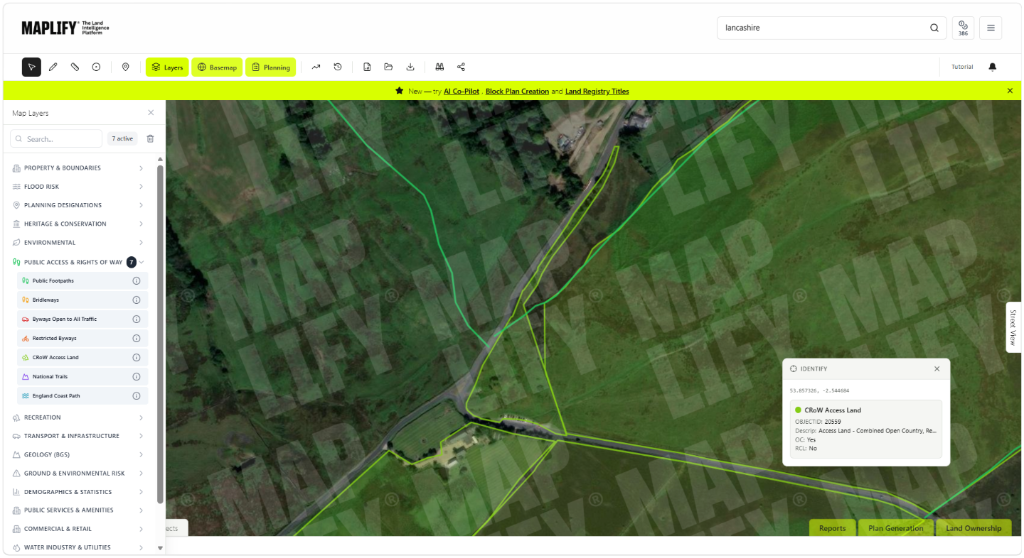
CRoW Access Land and rights of way enabled on the Maplify map, with an identify popup showing route details.
Planning and Development Implications
A right of way crossing a proposed development site must be retained, diverted through the appropriate formal process, or incorporated into the scheme layout — it cannot simply be built over or obstructed. Where a diversion is sought to enable development, consultation and confirmation by the relevant authority are required, and objections can extend the process.
CRoW open access land carries its own access rights separate from the definitive rights of way network, and development affecting access land needs to consider both the right of way network and the wider open access designation together.
What to Do When a Site Is Affected
- 1Confirm the exact route classification and status with the local highway authority's definitive map.
- 2If a route crosses a proposed development footprint, speak to the local highway authority early about the appropriate diversion or stopping-up process.
- 3Design layouts that retain or appropriately incorporate rights of way rather than obstructing them.
- 4Check for CRoW open access land status separately, since this is not always the same as a mapped right of way.
- 5Check the wider Planning Constraints and Green Belt layers for the same site for the fuller picture.
This is general guidance, not professional or legal advice — confirm specifics with the relevant authority or a qualified professional.
Official Data Source
Data Freshness
Important Limitations
- A route not shown on the definitive map may still exist as an unrecorded right of way — absence from the map is not conclusive proof a route does not exist.
- Diverting or extinguishing a right of way is a formal legal process that this map cannot initiate or predict the outcome of.
- Access restrictions (e.g. dog control on CRoW land during nesting season) are subject to change — confirm current rules with the relevant authority.
- This map is for screening; confirm details with the local highway authority before relying on them for a transaction.
Common Use Cases
Property Developers
Identify diversion requirements early in the site feasibility process.
Planning Consultants
Advise on the section 257 diversion process and timescales.
Architects
Design layouts that retain or incorporate rights of way appropriately.
Surveyors
Flag rights of way affecting privacy or value during property surveys.
Landowners
Understand access obligations before commissioning fencing or land management works.
Solicitors
Confirm right of way status during conveyancing due diligence.
Related Layers
Rights of way checks are commonly run alongside these related layers.
Related Guides
Frequently Asked Questions
How do I check if a footpath crosses my property?
Search the property on Maplify and enable the Public Rights of Way layer. Any footpath, bridleway or byway crossing the land will be shown, linked to the local authority's definitive map.
Can a landowner block a public right of way?
No. Landowners must not obstruct a right of way, and local authorities can enforce removal of any obstruction. Diversion is possible through a formal legal process, but simply blocking a route is not.
How can a footpath affect a property or development site?
A public footpath can affect privacy, layout and development feasibility because the legal route cannot simply be obstructed or built over. Buyers should confirm the definitive route and developers should account for it early in site design.
Can I apply to divert a right of way?
Yes. Where development makes a diversion necessary, a formal order may be pursued under the relevant legislation. The process involves consultation and can be delayed by objections, so confirm the correct route and procedure with the local highway authority early.
What is CRoW Act open access land?
Open access land under the Countryside and Rights of Way Act 2000 allows walking across mountain, moor, heath, down and common land — around 865,000 hectares in England — separate from the definitive rights of way network.
How current is the rights of way data?
Rights-of-way publication and update schedules vary by local highway authority. Maplify is useful for screening, but the authority’s definitive map and statement remains the legal record to verify for decision-critical use.
Check Rights of Way on Maplify
Open the map, generate a site report or save your search to come back to it later.
References and Methodology
Reviewed by the Maplify data & editorial team
Maplify displays official-source data for desktop screening and due diligence. We document where each dataset comes from, how it is processed, when it is checked and where its limitations matter.